This post contains affiliate links for which I may make a small commission to help keep the site running. You will not be charged extra for these items had you not clicked the links. Thank you for your help to keep the site running!
Ever seen Beverley Hills, 90210?
This is a classic example of a well-known American Zip code, and if you’re British, you’ll instantly recognize that it doesn’t follow the same format as a UK postcode?
So what’s the deal with zip codes?
And post codes?
And what does the UK city of Norwich have to do with it?
And why can’t you type in an American zip code in your GPS to get directions?
And what important British institution has the postcode, “W1N 4DJ” and why is this special?
I’m in the business of answering questions you’ve probably never asked yourself, so let’s sort through the world of UK postcodes and US zipcodes to help you understand the differences and why I think the UK has a more efficient system.

Watch on YouTube!
UK Postcodes vs USA Zip codes
Let’s start with the differences in the naming – essentially, we’re talking about a similar idea – we all know a postcode or zipcode come at the end of an address for further specification and sorting, and in the UK it’s called a post code, or postal code, and in the US it’s called a ZIP code – an acronym for Zone Improvement Plan, which to be honest I bet most Americans don’t know.
ZIP was also chosen in the US to indicate a “zipping” along of the mail, traveling faster when you use the code in the postal address.
How Many Houses they Cover
But these codes are actually quite different, firstly in the number of homes, residents, or land it covers.
In the UK, often we can tell each other directions by putting in the postcode.
I can type it into my GPS and be taken to the correct street, probably within just a few houses of the one I want – I will ultimately need the exact number to make sure I knock on the right door, but I don’t need to type in the full address to get there.
Postcodes in the UK cover an average of about 15 homes, but can be as few as one, or up to a maximum of around 100 which is for larger cities.
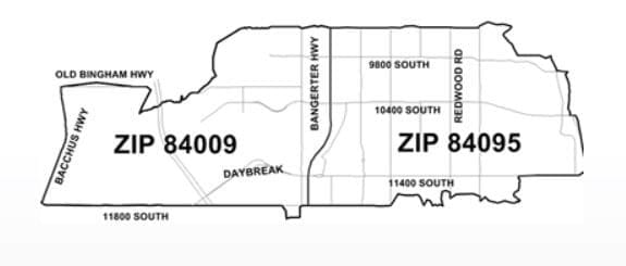
Standard Zipcodes in the US, on the other hand, cover large areas.
There’s one zipcode in Central Alaska that covers 13, 431 square miles.
The zip code I grew up in covers 17,696 housing units – they’re all in the same area, but you’re not going to just type in the zipcode and use it as directions unless you want to make 17,696 new friends (or enemies) while looking for the house you want.
So in the US, we don’t think of zipcodes in the same way that people think of postcodes in the UK because the UK version actually allows you to pinpoint streets and areas and be way more specific without needing to type out the entire address.
Your postcode is more unique to you in the UK and gives us much more information.
Now, there is a caveat to this – the US does have some “unique zip codes” assigned to large institutions like the CIA which has zip code 20505, however my point about not being able to use it as directions still stands.
You try typing this into Google maps, even in the US, and it just sort of gets confused and starts looking for all of the house numbers in the US that start with 20505 like 20505 Abrams Court in Brookeville Maryland and 20505 Little Creek Terrace in Ashburn Virginia.
Unless the CIA secretly operates out of residential looking new-built homes, which, you know, I guess that’s possible but probably not in this case.
Postcode and Zip code formats
Before we talk about the postcode and zip code history – don’t worry, we’re getting there, let’s talk about the format.
A US zip code is 5 digits – and it’s always digits, no lettering.
There used to be a more prevalent “Zip + 4” system that included 4 extra digits to indicate a more specific location sort of like the UK post code, but the public didn’t universally care or start using it and 9 numbers seems like a lot to remember so it’s been mostly ditched with modern technology.
Anyway, the first digit represents a group of US states, the second and third digit represent a region in that group (or a large city) and the 4th and 5th digits get more specific and represent a more specific area within that region – but again, it never gets as specific as the UK.
Cities may contain several zip codes and they do increase or decrease predictably sometimes – they increase as you go south along the Eastcoast – 02115 is Boston, 19103 is Philly, 30303 is Atlanta, and 33130 is Miami
Then, the numbers increase as you go west – 50309 is Des Moines Iowa, 63101 is St Louis, 80202 is Denver, 94111 is San Francisco and 99950 is in Alaska.
Also, as you can tell, the zip code is not divided up – it is all in one string of numbers.
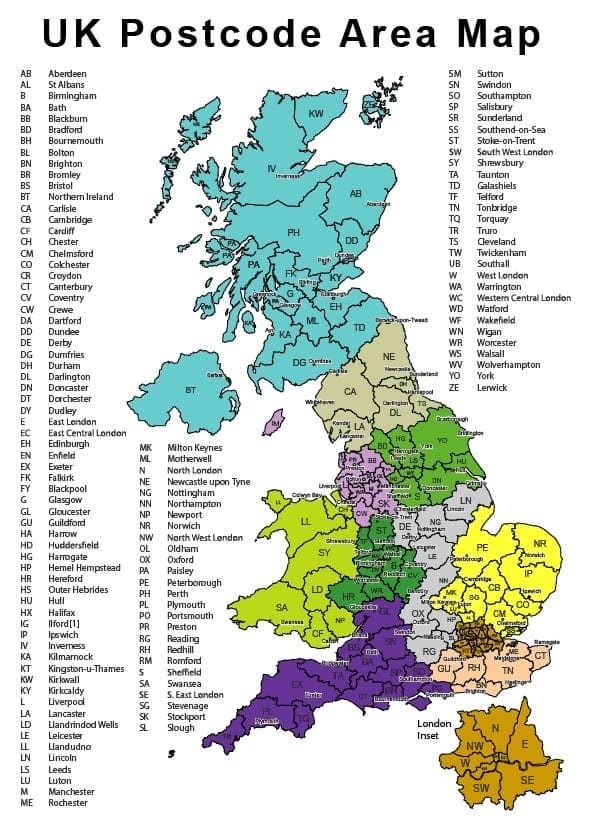
A UK postcode, on the other hand – is alphanumeric, with letters and numbers and it has 2 chunks.
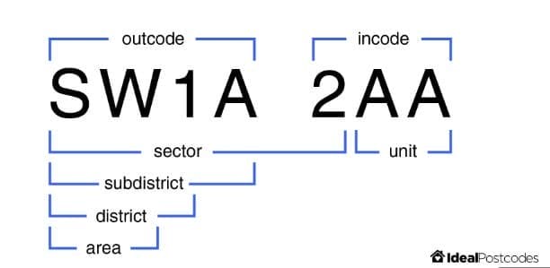
The first “chunk” is the outward code and has between 2 and 4 characters and shows the Post Town, which helps initially get the mail to the correct post office.
The second chunk always has 3 characters and points to a small group of addresses in that post town, as mentioned, usually around an average of 15 but definitely much smaller than a US zip code.
This is for internal use among in the local post office and begins with a number and then has 2 letters after.
The first letters, the postcode areas, are usually named after a major town or city, like B for Birmingham or G for Glasgow, but sometimes they get a little bit different and are named after smaller areas or an area further away, for instance, LL covers much of North Wales which has plenty of places without an LL in the name, and there’s a wide area in Buckinghamshire including places called Aylesbury and High Wycombe with an “HP” postcode, which is the Hemel Hempstead postcode – this is because the main sorting office is in Hemel Hempstead.
And London is broken up into postcodes based on a compass – so you’ll get E for East, NW for northwest, SE for southeast and so forth.
History of Postcodes and Zip codes
Let’s talk a little bit about how these codes came about, starting with the US.
The year is 1943 and many postal clerks are going into the army – suddenly, an influx of inexperienced postal clerks join and they need a way to more easily sort the mail without needing the time it takes to learn the delivery area of each city center.
So the United States Post Office Department implemented postal zones for 178 large cities, though they weren’t five digits at this point.
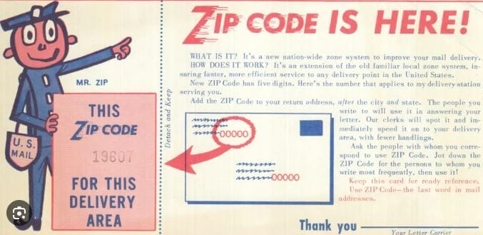
Decades later in the early 60s, the five digit ZIP code is born and introduced nationwide to help organize the mail even more, though it wasn’t mandatory at that point.
A man named Robert Moon is considered the “father of the zip code” and known as Mr. Zip, as he submitted this idea during his time as a postal inspector in Philadelphia, specifically the first three digits, with the idea that a standardized code could allow for machine sorting rather than hand sorting.
Zip codes became mandatory in 1967 and the US post office used a cartoon character to help the American public get used to the idea, including using the character along a musical group called the Swingin Six in a variety show to help explain the importance of using ZIP codes.
But what about UK post codes?
This obviously goes much further back than the US, and London was the first town to be divided up into postal districts, starting as early as 1857.
Other large cities caught on and places like Liverpool and Manchester were divided up into post zones in the 1860s.
This continued on a city by city basis for years until 1934 when the Post Office decided to introduce numbered districts or short post codes in every town in the UK they felt large enough to justify it – including 10 more areas including Birmingham, Brighton, Bristol, Leeds, and Sheffield.
They tried to encourage people to use the codes with their own marketing: a bit more dry than Mr. Zip, the slogan was “for speed and certainty always use a postal district number on your letters and notepad” but it got the point across.
But the modern postcode that we know it as today in the UK was a product of the 1950s, when electromechanical sorting machines allowed for more efficient and machine sorting.
The Post Office needed a town to essentially experiment with using the modern post codes, and Norwich was the winner because it already had 8 automatic mail sorting machines in use.
This is an interesting pamphlet showing Norwich residents more about the post code and how to use them.
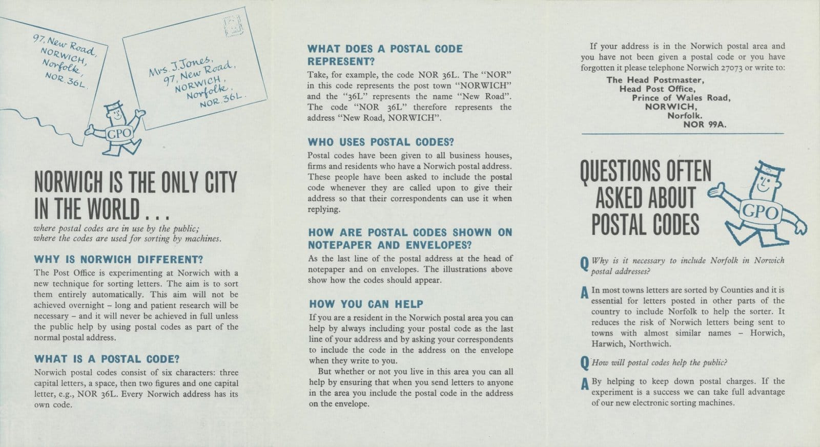
The experiment was a success and by 1965, it was announced that postal coding was going to be rolled out to the rest of the country.
In December of 1970, much of the Christmas mail was postmarked with the message “remember to use the postal code” and the scheme fully finished in 1974.
Special UK postcodes
We’ve talked about American institutions like the CIA that have their own zip code, but what about special postcodes in the UK?
I loved reading through this list of special postcodes – postcodes allocated by Royal Mail that cannot be purchased or specified, for high profile organizations.
These postcodes do not follow the same system as standard ones, as the letters in the second half are semi-mnemonic, meaning they are letters not following the internal sorting system of that region, but instead standing for something.
For example, Aston Martin ends in “0DB”, after their sports car DB. JP Morgan’s postcode ends in 5JP.
The Times Newspaper ends in 1TT. And BBC Radio 1 ends in 4DJ, standing for disc jockey.